Shop millions of independent artists. Independent. Together.


Nenagh, Ireland
$13.00
Title
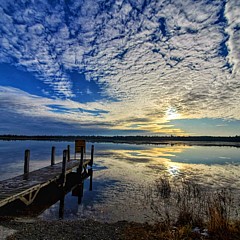
Flooded Fields
Artist
Rob Hemphill
Medium
Photograph - Photography
Description
There has been so much rain in the west of Ireland during the summer of 2020. Some fence lines in the fields are even partly under water. This image was taken on the southern edge of the Burren region in Co. Clare in Ireland. I particularly liked the combination of the reeds and water lillies adjacent to the fence.
The Burren (Irish: Boireann, meaning 'great rock') is a region of environmental interest primarily located in northwestern County Clare, Ireland, dominated by glaciated karst (or sometimes glaciokarst) landscape. It measures, depending on the definition, between 250 square kilometres (97 sq mi) and 560 square kilometres (220 sq mi). The name is most often applied to the area within the circle made by the villages of Tubber, Corofin, Kilfenora, Lisdoonvarna, and Ballyvaughan, and Kinvara in extreme south-western Galway, including the adjacent coastline.
A part of the Burren forms the Burren National Park, the smallest of the six National Parks in Ireland, while the full Burren and adjacent territory including the Cliffs of Moher are included in the Burren and Cliffs of Moher Geopark.
As the ice-cap moved into the Burren from the north-east it carried with it some debris, such as the granite boulders (Glacial erratics) on the coast line. However, the main action of the glacier was to scour the rock clean off any superficial cover that formerly may have lain on the surface, thus exposing and smoothly polishing the underlying bedrock which we know today as the largest classic karst limestone pavements in these islands. Pavements are made up of two separate but integral parts known as clints and grykes. Clints are the blocks of limestone that constitute the paving, their area and shape is directly dependant upon the frequency and pattern of grykes. Grykes are the fissures that isolate the individual clints. The most dominant gryke system runs almost north to south and there is a secondary less-developed system at right angles to it.
Grykes can stretch for hundreds of feet until they suddenly terminate or are lost beneath superficial deposits. Grykes are usually straight but are occasionally curvilinear.
***************************************************
Featured in the following FAA Groups:
"ABC Group" 01/04/2024
"Hodge Podge" 10/03/2020
"Your Very Best Photography" 09/19/2020
"Just Perfect" 09/16/2020
"Daily Promotion" 09/14/2020
"An Image Inspiring Meditation" 09/14/2020
"The Outdoor Photographer" 09/14/2020
"Fine Art America Professionals" 09/14/2020
"Water Forms" 09/13/2020
"Your Story of Art" 09/13/2020
***************************************************
Uploaded
September 13th, 2020
Statistics
Viewed 423 Times - Last Visitor from Fairfield, CT on 04/20/2024 at 4:14 AM
Embed
Sales Sheet
I'ina Van Lawick 13 Days Ago
Olympia, WA - United States
Beautilful landscape, Rob. Great composition and detail. LF
Western, IL - United States
Congratulations! Your wonderful art has been featured in ABC Group from our A is for AQUATIC themed week, September 18. 2023 - September 25, 2023.
Dayton, WA - United States
A fascinating image. When water is not where it "belongs," it makes a huge impact indeed. l/f/tweet/pin


Please Wait...
Sign up for our newsletter for exclusive deals, discount codes, and more.


Server Status OK
Copyright © 2024 Licensing.Pixels.com - All Rights Reserved


Share
Comment, Like, Favorite
0
0
0
0
0
87
0
65